
Niantic Spatial Wants to Give Machines a Working Map of the Physical World
Niantic Spatial has launched two connected products aimed at a problem that goes well beyond gaming: helping robots, industrial teams, and location-aware apps actually understand where they are in physical space. The company unveiled Scaniverse, an integrated web and mobile platform for capturing real-world spaces and turning them into usable spatial assets, alongside VPS 2.0, an updated version of its visual positioning system built to work at global scale.
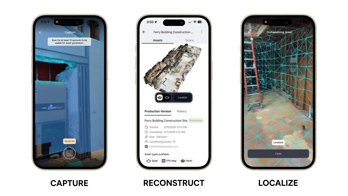
Niantic Spatial describes Scaniverse as the front door into its broader spatial intelligence services and Large Geospatial Model, letting users capture 3D spaces and generate visual positioning maps, meshes, and Gaussian splats from something as small as a single room up to areas spanning thousands of square meters. The platform works across consumer smartphones and 360-degree cameras, with support for additional capture types planned later this year. On mobile, users can build these maps from a single scan or stitch together multiple scans in the Scaniverse viewer, and multiple people can even contribute scans to the same shared project over time, with everything fused into one model as new data comes in. On-device VPS map previews let teams check coverage and quality on-site, even in places with poor connectivity, while the web version adds a browser-based portal for uploading, managing, and processing that same data, including reconstructing large areas from 360-degree footage as Gaussian splats, with finished assets exportable in FBX, PLY, and SPZ formats and convertible for use in robotics simulators.
VPS 2.0 is where things get more precise. In areas that have been mapped using Scaniverse, it can deliver six-degrees-of-freedom localization accurate to nearly a centimeter, a sharp contrast to the 3-to-5-meter accuracy typical of GPS under good conditions. Crucially, VPS 2.0 doesn't require a location to be pre-scanned to be useful at all; it can also work alongside GPS to provide three-degrees-of-freedom positioning, drawing on visual context and multiple data sources to correct for GPS drift and signal loss in places where satellite positioning alone tends to fall apart. The result, according to the company, is a single system that offers reliable positioning broadly through global VPS, then steps up to near-centimeter-accurate localization specifically in locations that have been mapped with Scaniverse.
Niantic Spatial is pitching the combined system at a fairly wide swath of industries: robotics companies whose machines operate indoors or in GPS-degraded environments, energy, construction, and logistics operations working across complex sites that benefit from a shared spatial model, public-sector environments where GPS reliability can't be taken for granted, and large venues looking to build persistent, location-aware applications. The company also confirmed that NSDK 4.0 will become generally available this month, adding support for Swift, Unity, and native Android, along with early ROS 2 support on request, giving developers a more direct path into both Scaniverse and VPS 2.0.